22,99 €
inkl. MwSt.
Versandkostenfrei*
Versandfertig in über 4 Wochen
payback
11 °P sammeln
  • Gebundenes Buch

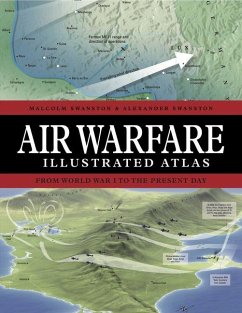
Air Warfare Illustrated Atlas is a highly illustrated, accessible account of the development of aerial warfare, from the first skirmishes in WWI to todayâ s hi-tech aerial battlespace. Featuring more than 120 maps and graphics, the book explores every major air battle, as well as describing the air element of major campaigns.

Produktbeschreibung
Air Warfare Illustrated Atlas is a highly illustrated, accessible account of the development of aerial warfare, from the first skirmishes in WWI to todayâ s hi-tech aerial battlespace. Featuring more than 120 maps and graphics, the book explores every major air battle, as well as describing the air element of major campaigns.
Autorenporträt
Malcolm Swanston has been writing and mapping history for over thirty years, working on subjects ranging from Ancient Rome to Vietnam and beyond. With his son Alexander, he has created maps detailing key events in warfare for a wide range of publications, including The Historical Atlas of World War II. Alexander Swanston has been writing and mapping history for a number of years, working on subjects ranging from Ancient Rome to Vietnam and beyond. With his father Malcolm, he has created maps detailing key events in warfare for a wide range of publications, including The Historical Atlas of World War II.