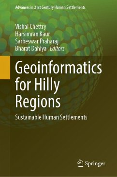
Geoinformatics for Hilly Regions
Sustainable Human Settlements
Herausgegeben:Chettry, Vishal; Kaur, Harsimran; Praharaj, Sarbeswar; Dahiya, Bharat
Geoinformatics for Hilly Regions
Sustainable Human Settlements
Herausgegeben:Chettry, Vishal; Kaur, Harsimran; Praharaj, Sarbeswar; Dahiya, Bharat
- Gebundenes Buch
- Merkliste
- Auf die Merkliste
- Bewerten Bewerten
- Teilen
- Produkt teilen
- Produkterinnerung
- Produkterinnerung
This book highlights the efficiency of geoinformatics to promote sustainable human settlements in hilly regions of India. It also serves as a platform to discuss the unique challenges and opportunities faced by hill settlements in fostering sustainable human settlements. With a focus on physical planning, environment, tourism, and climate change, this book equips planners, policymakers, and practitioners with the knowledge and tools necessary to make informed decisions and develop resilient strategies for these regions.
Andere Kunden interessierten sich auch für
![Warming Mountains Warming Mountains]() Warming Mountains121,99 €
Warming Mountains121,99 €![Urban Planning and Design for Megacities in the Global South Urban Planning and Design for Megacities in the Global South]() Urban Planning and Design for Megacities in the Global South113,99 €
Urban Planning and Design for Megacities in the Global South113,99 €![Impact of COVID-19 Lockdown on Environmental Health Impact of COVID-19 Lockdown on Environmental Health]() Abhijit MitraImpact of COVID-19 Lockdown on Environmental Health113,99 €
Abhijit MitraImpact of COVID-19 Lockdown on Environmental Health113,99 €![Warming Mountains Warming Mountains]() Warming Mountains106,99 €
Warming Mountains106,99 €![Communication, Science, Technology, and Innovation in Disaster Risk Management Communication, Science, Technology, and Innovation in Disaster Risk Management]() Communication, Science, Technology, and Innovation in Disaster Risk Management130,99 €
Communication, Science, Technology, and Innovation in Disaster Risk Management130,99 €![New Urban Agenda in Zimbabwe New Urban Agenda in Zimbabwe]() New Urban Agenda in Zimbabwe82,99 €
New Urban Agenda in Zimbabwe82,99 €![New Urban Agenda in Zimbabwe New Urban Agenda in Zimbabwe]() New Urban Agenda in Zimbabwe113,99 €
New Urban Agenda in Zimbabwe113,99 €-
-
-
This book highlights the efficiency of geoinformatics to promote sustainable human settlements in hilly regions of India. It also serves as a platform to discuss the unique challenges and opportunities faced by hill settlements in fostering sustainable human settlements. With a focus on physical planning, environment, tourism, and climate change, this book equips planners, policymakers, and practitioners with the knowledge and tools necessary to make informed decisions and develop resilient strategies for these regions.
Produktdetails
- Produktdetails
- Advances in 21st Century Human Settlements
- Verlag: Springer / Springer Nature Singapore / Springer, Berlin
- Artikelnr. des Verlages: 978-981-95-0155-7
- Seitenzahl: 236
- Erscheinungstermin: 19. November 2025
- Englisch
- Abmessung: 241mm x 160mm x 19mm
- Gewicht: 467g
- ISBN-13: 9789819501557
- ISBN-10: 9819501555
- Artikelnr.: 74770752
- Herstellerkennzeichnung
- Springer-Verlag KG
- Sachsenplatz 4-6
- 1201 Wien, AT
- ProductSafety@springernature.com
Dr. Vishal Chettry is currently working as Assistant Professor in the Department of Architecture, Planning and Design, IIT (BHU) Varanasi. He served as Assistant Professor at Manipal School of Architecture & Planning, MAHE Manipal, from July 2021 to March 2023. He also worked at Poornima University, Jaipur, from July 2016 to May 2017. His research interests include urban sprawl, urban sustainability, urban heat island, and the application of RS and GIS in the urban and regional planning domain. Dr. Harsimran Kaur is Certified Indian Green Building Council Accredited Professional (IGBC-AP) and Assistant Professor at the Department of Architecture, Planning, and Design at IIT (BHU) in Varanasi, India. She engages in research in the areas of urban sustainability, hillside planning and development, heritage conservation, applications of AR and VR in architecture and planning, spatial analytics, and data visualization. Dr. Sarbeswar Praharaj is Assistant Professor at the University of Miami, USA. He works as Bridge between UM’s Department of Geography and Sustainable Development and the School of Architecture. He plays a critical role within the University of Miami’s flagship Climate Resilience Academy at the forefront of advancing sustainability and resilience to climate change. He was previously appointed as Associate Director and Assistant Research Professor at the Knowledge Exchange for Resilience at Arizona State University. His research and teaching interests combine critical applications of geospatial data science and smart cities’ foundations for shaping more inclusive, sustainable, and resilient communities. He holds a Ph.D. in urban planning and was also a postdoctoral researcher and manager of the City Analytics Lab within the City Futures Research Center at UNSW Sydney. Dr. Bharat Dahiya is Director of Research Center for Sustainable Development and Innovation at the School of Global Studies, Thammasat University, Thailand. He is Extraordinary Professor at the School of Public Leadership, Stellenbosch University, Western Cape, South Africa, and Adjunct Faculty at the Asian Institute of Technology, Thailand. An award-winning urbanist, Bharat combines cutting-edge research, policy analysis, and development practice aimed at examining and tackling socio-economic, environmental, and governance issues in the global urban context of sustainable development. Since the early-1990s, his research and professional work has focused on sustainable cities and urbanization, strategic urban planning and development, urban infrastructure, urban environment, climate change and urban resilience, post-disaster recovery and reconstruction, and cultural heritage and landscapes.
Introduction: Geoinformatics for Sustainable Human Settlements in Hilly Regions.- Sustainable Urban Development in Hilly Regions:Concepts, Evolution, and Challenges.- Land Use Planning in Hill cities of India and Abroad: A Comparative Study.- Sustainable land-use planning in environmental sensitive Hill city Gangtok, India.- The impact of culture, climate, topography, and geology on settlements in hilly areas: A case of Kandad, India.- Accessibility for Senior Citizens in Hill Settlements: Challenges and Opportunities for Sustainable Mobility.- Assessment of urban growth dynamics in Srinagar (J&K), India.- Satellite Remote Sensing Techniques for Air Quality Monitoring in the Mid-Brahmaputra Valley of Northeast India.- Spatio-Temporal Comparative Study of Aerosol Optical Depth, Aerosol Index, and Planetary Boundary Layer Height During and After COVID-19 Lockdown over North Eastern Region of India.- Geoinformatics for Climate Change Vulnerability Assessment in the Western Himalayan Cities.- Assessing and Mapping Tourism Vulnerability using Remote Sensing and Spatial Analysis Techniques: A Case of Shimla District in Himachal Pradesh, India.- Safeguarding the Western Himalayas: Sustainable Disaster Management in the Hilly Regions of Himachal Pradesh.- Issues, Options and Strategies for making Hill Habitat Inclusive, Safe, Resilient and Sustainable.- Academic Contribution and Policy Perspectives: Geoinformatics for Sustainable Human Settlements in Hilly Regions.
Introduction: Geoinformatics for Sustainable Human Settlements in Hilly Regions.- Sustainable Urban Development in Hilly Regions:Concepts, Evolution, and Challenges.- Land Use Planning in Hill cities of India and Abroad: A Comparative Study.- Sustainable land-use planning in environmental sensitive Hill city Gangtok, India.- The impact of culture, climate, topography, and geology on settlements in hilly areas: A case of Kandad, India.- Accessibility for Senior Citizens in Hill Settlements: Challenges and Opportunities for Sustainable Mobility.- Assessment of urban growth dynamics in Srinagar (J&K), India.- Satellite Remote Sensing Techniques for Air Quality Monitoring in the Mid-Brahmaputra Valley of Northeast India.- Spatio-Temporal Comparative Study of Aerosol Optical Depth, Aerosol Index, and Planetary Boundary Layer Height During and After COVID-19 Lockdown over North Eastern Region of India.- Geoinformatics for Climate Change Vulnerability Assessment in the Western Himalayan Cities.- Assessing and Mapping Tourism Vulnerability using Remote Sensing and Spatial Analysis Techniques: A Case of Shimla District in Himachal Pradesh, India.- Safeguarding the Western Himalayas: Sustainable Disaster Management in the Hilly Regions of Himachal Pradesh.- Issues, Options and Strategies for making Hill Habitat Inclusive, Safe, Resilient and Sustainable.- Academic Contribution and Policy Perspectives: Geoinformatics for Sustainable Human Settlements in Hilly Regions.

