- Gebundenes Buch
- Merkliste
- Auf die Merkliste
- Bewerten Bewerten
- Teilen
- Produkt teilen
- Produkterinnerung
- Produkterinnerung
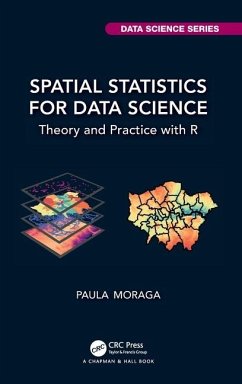
Spatial data is crucial to improve decision-making in a wide range of fields including environment, health, ecology, urban planning, economy, and society. This book describes statistical methods, modeling approaches, and visualization techniques to analyze spatial data using R.
Andere Kunden interessierten sich auch für
![Handbook of Spatial Epidemiology Handbook of Spatial Epidemiology]() Handbook of Spatial Epidemiology78,99 €
Handbook of Spatial Epidemiology78,99 €![Data Science in Practice Data Science in Practice]() Tom AlbyData Science in Practice94,99 €
Tom AlbyData Science in Practice94,99 €![Basketball Data Science Basketball Data Science]() Paola Zuccolotto (Italy University of Brescia)Basketball Data Science80,99 €
Paola Zuccolotto (Italy University of Brescia)Basketball Data Science80,99 €![Getting (more out of) Graphics Getting (more out of) Graphics]() Antony Unwin (University of Augsburg)Getting (more out of) Graphics102,99 €
Antony Unwin (University of Augsburg)Getting (more out of) Graphics102,99 €![Hierarchical Modeling and Analysis for Spatial Data Hierarchical Modeling and Analysis for Spatial Data]() Sudipto Banerjee (University of California Los Angeles)Hierarchical Modeling and Analysis for Spatial Data147,99 €
Sudipto Banerjee (University of California Los Angeles)Hierarchical Modeling and Analysis for Spatial Data147,99 €![Probability and Statistics for Data Science Probability and Statistics for Data Science]() Norman MatloffProbability and Statistics for Data Science80,99 €
Norman MatloffProbability and Statistics for Data Science80,99 €![Geographic Data Science with Python Geographic Data Science with Python]() Sergio ReyGeographic Data Science with Python94,99 €
Sergio ReyGeographic Data Science with Python94,99 €-
-
-
Spatial data is crucial to improve decision-making in a wide range of fields including environment, health, ecology, urban planning, economy, and society. This book describes statistical methods, modeling approaches, and visualization techniques to analyze spatial data using R.
Produktdetails
- Produktdetails
- Chapman & Hall/CRC Data Science Series
- Verlag: Taylor & Francis Ltd
- Seitenzahl: 298
- Erscheinungstermin: 8. Dezember 2023
- Englisch
- Abmessung: 240mm x 161mm x 21mm
- Gewicht: 610g
- ISBN-13: 9781032633510
- ISBN-10: 1032633514
- Artikelnr.: 69031990
- Herstellerkennzeichnung
- Libri GmbH
- Europaallee 1
- 36244 Bad Hersfeld
- gpsr@libri.de
Paula Moraga is Professor of Statistics at King Abdullah University of Science and Technology (KAUST). She received her Master's in Biostatistics from Harvard University and her Ph.D. in Mathematics from the University of Valencia. Dr. Moraga develops innovative statistical methods and open-source software for spatial data analysis and health surveillance, including R packages for spatio-temporal modeling, detection of clusters, and travel-related spread of disease. Her work has directly informed strategic policy in reducing the burden of diseases such as malaria and cancer in several countries. Dr. Moraga has published extensively in leading journals, and serves as an Associate Editor of the Journal of the Royal Statistical Society Series A. She is the author of the book Geospatial Health Data: Modeling and Visualization with R-INLA and Shiny (Chapman & Hall/CRC). Dr. Moraga received the prestigious Letten Prize for her pioneering research in disease surveillance, and her significant contributions to the development of sustainable solutions for health and environment globally.
Part 1: Spatial data 1. Types of spatial data 2. Spatial data in R 3. The
sf package for spatial vector data 4. The terra package for raster and
vector data 5. Making maps with R 6. R packages to download open spatial
data Part 2: Areal data 7. Spatial neighborhood matrices 8. Spatial
autocorrelation 9. Bayesian spatial models 10. Disease risk modeling 11.
Areal data issues Part 3: Geostatistical data 12. Geostatistical data 13.
Spatial interpolation methods 14. Kriging 15. Model-based geostatistics 16.
Methods assessment Part 4: Spatial point patterns 17. Spatial point
patterns 18. The spatstat package 19. Spatial point processes and
simulation 20. Complete Spatial Randomness 21. Intensity estimation 22. The
K-function 23. Point process modeling Appendix A. The R software

