24,99 €
inkl. MwSt.
Versandkostenfrei*
Versandfertig in 1-2 Wochen
payback
12 °P sammeln
  • Broschiertes Buch

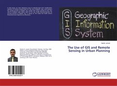
In this study, our main objectives were to identify best LULC classification method of remote sensing data for the city of Riyadh; map, and measure the spatial growth of Riyadh city; predict the future growth of the city; and to compare with master plan of the city, finally recommendation to control growth of Riyadh city. In doing so, this study has made several theoretical and empirical contributions.

Produktbeschreibung
In this study, our main objectives were to identify best LULC classification method of remote sensing data for the city of Riyadh; map, and measure the spatial growth of Riyadh city; predict the future growth of the city; and to compare with master plan of the city, finally recommendation to control growth of Riyadh city. In doing so, this study has made several theoretical and empirical contributions.
Autorenporträt
Nadim A. Jamali, Nawabshah, Paquistão, 3 de maio de 1985. Mestre em Planeamento Urbano e Regional, Universidade Rei Fahd de Petróleo e Minerais (KFUPM), Dhahran, Arábia Saudita, 2015. Bacharelato em Planeamento Urbano e Regional, Universidade de Engenharia e Tecnologia de Mehran (MUET), Jamshoro, Paquistão, 2010. Trabalha como SR. Urbanista.