Sie sind bereits eingeloggt. Klicken Sie auf 2. tolino select Abo, um fortzufahren.
Bitte loggen Sie sich zunächst in Ihr Kundenkonto ein oder registrieren Sie sich bei bücher.de, um das eBook-Abo tolino select nutzen zu können.
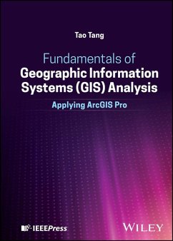
Unique and authoritative reference combining concepts, theories, and hands-on analysis in the ArcGIS Pro software environment Fundamentals of Geographic Information Systems (GIS) Analysis bridges the gap between academic discussions and research with public and private professional practices in the field. The book discusses and illustrates essential concepts and theories, with tutorials showing students how to conduct hands-on analysis in the ArcGIS Pro software environment. Supplementary material for this text includes data files for the tutorials and student exercises. All datasets are…mehr
Unique and authoritative reference combining concepts, theories, and hands-on analysis in the ArcGIS Pro software environment
Fundamentals of Geographic Information Systems (GIS) Analysis bridges the gap between academic discussions and research with public and private professional practices in the field. The book discusses and illustrates essential concepts and theories, with tutorials showing students how to conduct hands-on analysis in the ArcGIS Pro software environment.
Supplementary material for this text includes data files for the tutorials and student exercises. All datasets are sourced from public domains, including the US Census Bureau data, the New York State ITS Geospatial Services, the New York State Department of Environmental Conservation (NYSDEC), the GIS Services of Erie County New York, and others.
Written by a highly qualified academic, the book covers topics such as:
Digital data models representing geographic information, including vector, raster, and 3D models
Methods of spatial data input in vector and raster data formats to incorporate geographic features and events with their attribute data
Geographic data collections in natural sciences, engineering, and social sciences, and relational, spatial, and structural querying of a database
Coordinate systems, map projection, geo-referencing, geographic analyses, and internet-enabled geographic information sharing
Spatial interpolation and spatial statistical analysis, network analysis, digital mapping, and map presentations
Fundamentals of Geographic Information Systems (GIS) Analysis is an essential reference for GIS analysts and technicians, urban planners, civil engineers, and computer scientists, along with students in related programs of study.
Dieser Download kann aus rechtlichen Gründen nur mit Rechnungsadresse in D ausgeliefert werden.
Die Herstellerinformationen sind derzeit nicht verfügbar.
Autorenporträt
Tao Tang is a Professor of Geographic Information Systems (GIS) and Remote Sensing in the Department of Geosciences at Buffalo State University and The State University of New York (SUNY). Along with GIS and remote sensing, he also teaches map interpretation, physical geography, and the geography of Asia. Some of his research interests include slope form and processes, environmental modeling, and watershed management.
Inhaltsangabe
Table of Contents Preface Acknowledgement About the author 1. Foundations of Geographic Information Systems (GIS) Chapter 1. Introduction to Analyses in Geographic Information Systems (GIS) A) Concepts and Theories B) Tutorial in ArcGIS-Pro Environment Chapter 2. Digital Data Models Representing Geographic Information A) Concepts and Theories 1. Vector model 2. Raster model 3. 3D model B) Tutorial in ArcGIS-Pro Environment 2. Fundamentals of Geographic Information Data Processing Chapter 3. Geographic Information Database and Database Management A) Concepts and Theories 1. Methods of spatial data input in vector and raster data formats. 2. Incorporating geographic features and events with their attribute data 3. Relational database, spatial and structural querying of database B) Tutorial in ArcGIS-Pro Environment Chapter 4. Geographic Information Data Gathering and Data Collections A) Concepts and Theories 1. Geographic information primary data collections 2. Geographic data collections in natural sciences and engineering 3. Geographic data collections in social sciences 4. Surveying and remote sensing as the methods of geographic information data collections 5. Existing data gathering, online geographic data capture, and data conversions. B) Tutorial in ArcGIS-Pro Environment Chapter 5. Coordinate Systems, Map projection and Geo-referencing in GIS A) Concepts and Theories 1. Absolute geographic coordinate systems 2. Relative geographic coordinate systems. B) Tutorial in ArcGIS-Pro Environment 3. Fundamentals of Geographic Information Analysis Chapter 6. Basic Spatial (Geographic) Analyses in Vector Data Environment A) Concepts and Theories B) Tutorial in ArcGIS-Pro Environment Chapter 7. Basic Spatial (Geographic) Analyses in Raster Data Environment A) Concepts and Theories B) Tutorial in ArcGIS-Pro Environment Chapter 8. Three-dimensional (3D) Spatial (Geographic) Analyses A) Concepts and Theories B) Tutorial in ArcGIS-Pro Environment 4. Advanced Concepts and Applications of Geographic Information Analysis Chapter 9. Spatial Interpolation and Spatial Statistical Analysis A) Concepts and Theories B) Tutorial in ArcGIS-Pro Environment Chapter 10. Network Analysis A) Concepts and Theories 1. Utility network analysis 2. Fully functioning (transportation) network analysis B) Tutorial in ArcGIS-Pro Environment Chapter 11. Spatial (Geographic) Modeling in GIS and Issues of GIS Software Enhancement A) Concepts and Theories 1. Spatial and distributed modeling in natural environment 2. Spatial and distributed modeling in human built-up society 3. Software enhancement B) Tutorial in ArcGIS-Pro Environment 5. Geographic Information Presentations and Digital Mapping Chapter 12. Digital mapping, map presentations, cartography, and geographic information sharing - a summary A) Concepts and Theories B) Tutorial in ArcGIS-Pro Environment
Es gelten unsere Allgemeinen Geschäftsbedingungen: www.buecher.de/agb
Impressum
www.buecher.de ist ein Internetauftritt der buecher.de internetstores GmbH
Geschäftsführung: Monica Sawhney | Roland Kölbl | Günter Hilger
Sitz der Gesellschaft: Batheyer Straße 115 - 117, 58099 Hagen
Postanschrift: Bürgermeister-Wegele-Str. 12, 86167 Augsburg
Amtsgericht Hagen HRB 13257
Steuernummer: 321/5800/1497
USt-IdNr: DE450055826