21,99 €
inkl. MwSt.
Versandkostenfrei*
Versandfertig in 2-4 Wochen
payback
11 °P sammeln
  • Landkarte

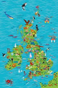
Colourful Illustrated Map of the United Kingdom and Ireland This highly illustrated, rolled pictorial map is designed to take children on a journey of discovery around the United Kingdom and Ireland. Stunning illustrations are used to depict themes such as national emblems, customs, food, birds, animals, buildings and sports to help younger readers gain an understanding of peoples around the world. Illustrated by Steve Evans.

Produktbeschreibung
Colourful Illustrated Map of the United Kingdom and Ireland This highly illustrated, rolled pictorial map is designed to take children on a journey of discovery around the United Kingdom and Ireland. Stunning illustrations are used to depict themes such as national emblems, customs, food, birds, animals, buildings and sports to help younger readers gain an understanding of peoples around the world. Illustrated by Steve Evans.
Hinweis: Dieser Artikel kann nur an eine deutsche Lieferadresse ausgeliefert werden.
Autorenporträt
Collins makes books full of ideas, creativity, hands-on activities and opportunities to find out more about the things that interest children. We want our books to inspire and entertain them, celebrate their passions and interests and support their emotional wellbeing. We also want to help children be aware of our impact on the planet, which is why all of our books are carefully made with responsibly sourced materials.